Amber Forecast for Baltic Beaches
Find out when and where to find amber on the Baltic Sea. Don't waste a trip on an empty beach — our 10-day forecast for Baltic coast regions shows you exactly where to go.
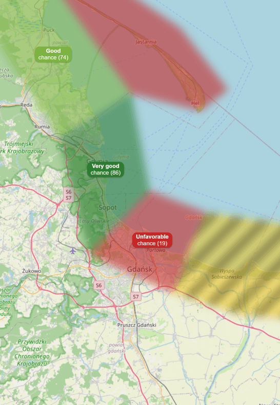
Interactive map — click to open
How does amber forecasting work?
Weather data
Every hour we fetch wind, wave, and sea level data for the entire coastline
Physical model
AmberMap's physics engine analyses weather conditions in real time and evaluates how they affect the chance of amber appearing
Local beach characteristics
Each coastal region responds differently — we factor in local beach characteristics to assess the chance for every section
Forecast map
Coastal regions are highlighted with colors based on the chance of finding amber
When to search for amber on the Baltic?
Amber washes up on Baltic beaches mainly after strong autumn and winter storms, especially from October through March. But a storm alone isn't enough — you need sustained onshore winds, tall waves with a long period, and favorable sea levels. The exact wind direction depends on how the coast faces: northern winds work best for Poland and Germany, while southwest winds push amber ashore in Latvia and Lithuania. Without that combination, the beach stays empty.
The best time to search is a few hours after a storm passes, when waves are still subsiding but the sea keeps pushing material ashore. That's the narrow window most people miss. AmberMap tracks these conditions in real-time and pinpoints the exact moment for each stretch of coast.
Search early in the morning, in low sunlight, when amber is easier to tell apart from stones on wet sand. Look in the drift line between seaweed, driftwood, and shells — amber has a similar density to wood and collects in the same spots. Many experienced hunters bring UV flashlights — amber glows under ultraviolet light, making it unmistakable even in poor visibility.
Where to find amber – the best spots on the Baltic
The richest amber deposits in the world lie beneath the Sambia Peninsula near Kaliningrad, and the entire southern Baltic coast benefits from this source. Poland's Vistula Spit and Gdańsk Bay — particularly Jantar (the 'amber capital'), Sobieszewo Island, Mikoszewo, and Stegna — are the most productive accessible beaches in Europe. Further west, Hel Peninsula, Łeba, and Ustka also yield good finds. Germany's Mecklenburg-Vorpommern coast (Darß, Usedom, Rügen, Hiddensee) is another strong region. Lithuania's Curonian Spit and Palanga have been amber-hunting grounds for centuries, and Latvia's Kurzeme coast around Liepāja and Pavilosta is known for generous deposits. Even Denmark's North Sea coast and Sweden's Falsterbo peninsula see amber after heavy storms. AmberMap monitors coastal regions across the Baltic and accounts for differences in seabed slope, wave exposure, and proximity to underwater amber deposits.
Amber guides
Before you head to the beach: how to identify amber, when and where to look after a storm, and what gear to use.
Why is there less amber in summer
The “warm water” myth busted with numbers. What really drives the season: storms, sea stratification and water viscosity — with charts.
How to identify amber
Field and home tests (weight, UV, salt water), what amber is confused with, and how to avoid the dangerous white-phosphorus lookalike.
When to find amber
Season, the post-storm window, time of day, and which winds favour amber on the Baltic.
Amber after a storm: how and where
How to read the strandline and exactly where amber settles on the beach after a storm.
How to read the map — scores, colours, and warnings
Each coastal region has an amber-chance score — a number from 0 to 100 displayed on the region — and a colour that matches the score. Higher score, better conditions for amber.
Amber index and conditions index
- Amber index — the default view — combines current sea & weather conditions with how much amber the beach holds; shows where the real chance of a find is highest.
- Conditions index (Premium) — rates the sea & weather conditions alone, ignoring the beach's amber richness.
Colour scale (5 levels)
- 80–100 · Very good — Best moment — waves and wind are working in your favour.
- 60–79 · Good — A real chance of a successful search.
- 40–59 · Moderate — Decent conditions, but no guarantees.
- 20–39 · Low — Slim chances — more of a walk than a hunt.
- 0–19 · Unfavorable — No realistic chance under these conditions.
Estimated amber quantity
After signing in, each hour also shows an indicative amber-quantity range (in grams). The estimate depends on conditions and the beach's richness.
Safety warnings
- Ice danger — Stay out of the water — slush and freezing temperatures.
- High waves — Wading is dangerous — waves exceed the safety threshold for that beach.
- Beach inaccessible — Flooded or cut off by the storm.
Important: when the score is high but you see a warning, amber is in the water but conditions are too dangerous to collect it. Wait for the warning to clear — that's often the best moment.
How accurate is the forecast?
The forecast updates every hour. The closest 1–2 days are the most reliable — beyond that, the error margin grows. This is not an AmberMap engine bug; it's the inherent limit of the weather forecast (wind, waves, sea level) we feed into the model. The further out, the less precise those weather inputs become. For the 5–10 day horizon, treat the forecast as an early signal and re-check 1–2 days before heading out.
Frequently asked questions
When is the best time to search for amber on the Baltic?
Where are the best places to find amber on the Baltic Sea?
How does the AmberMap amber forecast work?
How do I recognize real amber on the beach?
Is AmberMap free?
What weather conditions favor amber hunting?
We’ll tell you when amber starts washing up
Leave your email and we’ll let you know when conditions on the Baltic coast point to a good day for amber. Now and then we’ll add some AmberMap news.
Check the amber forecast now
Could today be the day? Open the map and check which beaches have the best conditions right now.