The 8 July 2026 storm: a July sea with winter force
On Wednesday 8 July 2026 a storm hits the beaches of the Gulf of Gdańsk — from Sobieszewo Island through Mikoszewo, Jantar, Stegna and Sztutowo to Krynica Morska — with waves up to 3.7 m and a wind from the north-west, i.e. straight off the sea. In separate sections we also cover the open coast from Kołobrzeg to Hel, where the wave reaches 2.5–3.1 m. This post is based on the forecast from the evening of Tuesday 7 July.
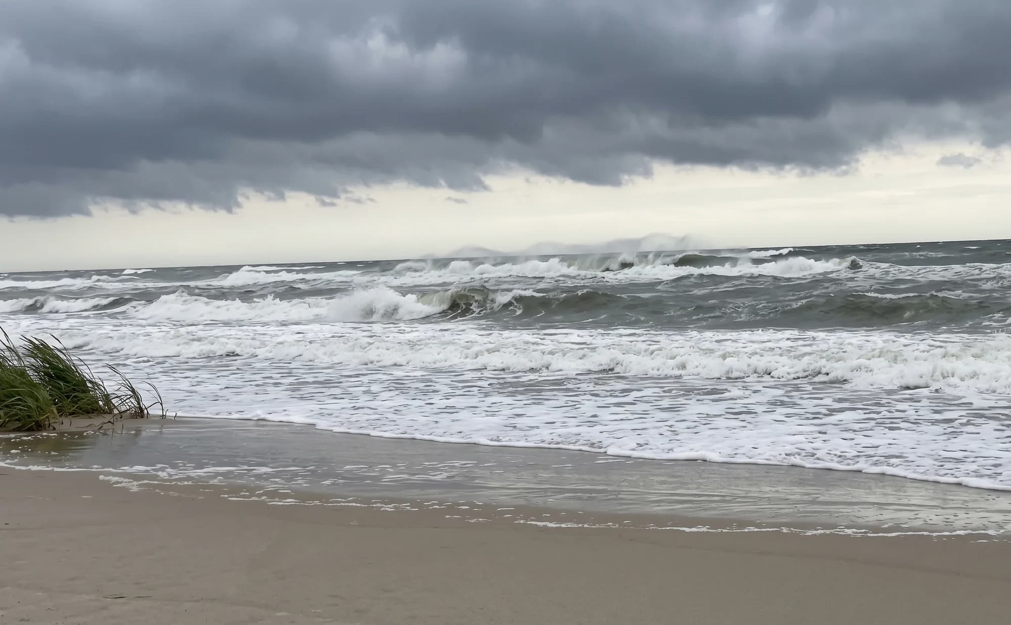
A deep low is sliding down over the Baltic from Scandinavia — described by weather services as Cyclone Bernadetta[4] — and Poland’s IMGW weather service is issuing strong-wind warnings for the coast[3]. On the Gulf of Gdańsk the wave forecast[1] shows a Wednesday peak of 2.6–3.7 m (rising towards the east) with winds of up to about 19 m/s from the north-west and gusts reaching ~90–96 km/h at the shore. The open coast from Kołobrzeg to Hel gets hit hard too — though, as we’ll show, without setting a summer record: there the forecast gives 2.5–3.1 m, and the peak passes earlier, already overnight from Tuesday into Wednesday.
To be clear about how unusual this is: in our Baltic weather archive, which goes back to January 2023[2], no summer day on the Sobieszewo–Krynica Morska stretch has come close to waves this big. This is the kind of sea this piece of coast sees a handful of times in the depths of winter — and practically never in July.
And to be honest right away: a strong onshore storm is a favourable set-up, not a guarantee of amber. Below we break the storm down hour by hour — first for the Gulf of Gdańsk and the Vistula Spit, then separately for the open coast — compare it with previous years, and say when, where and whether it’s even worth heading to the beach afterwards.
The Gulf of Gdańsk and the Vistula Spit — hour by hour: the peak on Wednesday morning
This section and the next two cover the Gulf of Gdańsk stretch from Sobieszewo Island to Krynica Morska (the open coast gets its own sections below). Here the wave starts building already on Tuesday evening, passes 1.5–2 m overnight, and reaches its peak on Wednesday between about 08:00 and 11:00 local time. Then the storm slowly relents: by Wednesday evening the wave drops to around 2 m, on Thursday it holds at about 2 m with the wind veering to the north, and on Friday the sea gradually calms.
The force isn’t spread evenly: the further east, the stronger. At Sobieszewo Island the forecast peak is about 2.6 m, at Jantar 3.3 m, at Stegna 3.6 m, and at Krynica Morska — 3.7 m.
The four Gulf of Gdańsk stretches in numbers
Here is the forecast peak of Wednesday’s storm for each stretch of the Gulf — from Sobieszewo Island to Krynica Morska. The wind blows from the north-west on all of them — that is, off the sea, straight onshore.
| Stretch | Peak wave (forecast) | Peak time (Wed 8 Jul) | Max wind | Gusts |
|---|---|---|---|---|
| Sobieszewo Island | 2.6 m | late morning (~11:00) | ≈ 19 m/s, NW (onshore) | up to ~96 km/h |
| Mikoszewo–Jantar | 3.3 m | morning (~08:00) | ≈ 18.5 m/s, NW (onshore) | up to ~90 km/h |
| Stegna–Sztutowo | 3.6 m | morning (~08:00) | ≈ 18.6 m/s, NW (onshore) | up to ~93 km/h |
| Krynica Morska–Piaski | 3.7 m | late morning (~11:00) | ≈ 19 m/s, NW (onshore) | up to ~94 km/h |
The Gulf of Gdańsk against previous years
In our guide on why there’s less amber in summer, we showed that on the Polish coast the summer months deliver only a fraction of the winter storms. Wednesday’s storm is a spectacular exception to that rule — we’ve set it against the strongest summer day of each of the past three years on that same Sobieszewo–Krynica Morska stretch.
The previous summer “record” for this piece of coast in our archive is 2.7 m, on 11 July 2025 — almost exactly a year ago. Summer 2024 never topped 2.0 m, and summer 2023 not even 1.6 m. The forecast 3.3 m (averaged across the four stretches) beats all of that by a clear margin.
The whole-year comparison lands even harder: in the archive since January 2023 (1,247 days) only 6 days had a bigger wave on this stretch — all in the colder half of the year, led by a run around the turn of December 2025 into January 2026. So Wednesday will be a day of a force this shore sees at most a few times per winter.
And when did a summer storm of this class last hit the Polish coast anywhere? In our archive you have to go back to 7–8 August 2023, when on the middle coast (around Jarosławiec) the wave reached about 3.6 m[2]. On the Gulf of Gdańsk itself there is no comparably strong summer day in the archive at all. What Wednesday’s storm does on the open coast is the subject of the next two sections.
The open coast, from Kołobrzeg to Hel: strong too, but the peak comes at night
This section and the next cover the open sea — the stretch from Kołobrzeg through Ustka and Łeba to the Hel Peninsula (on its open-Baltic side). The same low hits here too: the forecast[1] gives waves of 2.5–3.1 m with a north-westerly wind — on this coast, too, off the sea and straight onshore. The eastern part gets it hardest: Karwia–Dębki (about 3.1 m) and the Hel Peninsula, where gusts may reach ~105 km/h.
The key difference from the Gulf of Gdańsk: the peak passes earlier here. On the middle coast (Kołobrzeg–Ustka–Rowy) the wave culminates already overnight from Tuesday into Wednesday, around 02:00, at Łeba in the early morning, and at Karwia and on the Hel Peninsula around 08:00 — and then falls throughout Wednesday.
The further west, the weaker: Rewal about 2.2 m, Międzyzdroje about 1.6 m, and Świnoujście — partly sheltered from the NW — barely about 0.8 m, which is why the western end of the coast isn’t in the table below.
| Stretch | Peak wave (forecast) | Peak time | Max wind | Gusts |
|---|---|---|---|---|
| Kołobrzeg–Mielno | 2.5–2.6 m | overnight Tue–Wed (~02:00) | ≈ 16.5 m/s, NW (onshore) | up to ~82 km/h |
| Darłowo–Jarosławiec | 2.5–2.6 m | overnight Tue–Wed (~02:00) | ≈ 16 m/s, NW (onshore) | up to ~87 km/h |
| Ustka and Czołpino–Rowy | 2.5–2.6 m | overnight Tue–Wed (~02:00) | ≈ 16.5 m/s, NW (onshore) | up to ~82 km/h |
| Łeba | 2.7 m | early morning (~05:00) | ≈ 17 m/s, NW (onshore) | up to ~81 km/h |
| Karwia–Dębki | 3.1 m | morning (~08:00) | ≈ 18.7 m/s, NW (onshore) | up to ~92 km/h |
| Hel Peninsula (Władysławowo–Hel, open-sea side) | 2.6 m | morning (~08:00) | ≈ 21 m/s, NW (onshore) | up to ~105 km/h |
The open coast against previous years: the strongest since August 2023, but no record
For the Kołobrzeg–Hel stretch we compute the same index as for the Gulf: the average of daily wave maxima at nine marine points. The forecast 2.6 m for Wednesday is the strongest summer day on this coast since 7–8 August 2023 — in the whole archive only those two summer days were higher[2].
Unlike the Gulf, though, this won’t be a summer record: the August 2023 storm was clearly stronger here (index 3.0 m, locally about 3.6 m at Jarosławiec). There’s a second difference too: on the open sea a wave like this is a rarity only in summer. Across the whole year the archive has 46 days out of 1,247 with a bigger wave — so the open coast sees these conditions a dozen or more times a year, mainly in autumn and winter. On the Gulf there were just 6 such days. It’s the same wave — but for the Gulf’s beaches a far rarer, and therefore potentially more interesting, event.
Will this storm bring amber? (both stretches of coast)
This section covers the whole coast described above — the Gulf of Gdańsk and the open sea. The honest answer: the set-up is favourable, but there’s no guarantee. As we explain in our guide on when to find amber, the chance of a wash-up comes down to three things at once: wave strength (it has to lift sediment off the seabed), direction (wind and waves pressing in from the sea carry material shorewards) and duration. Wednesday’s storm has all three on both stretches: a winter-strength sea, an NW wind straight onshore, and well over a dozen hours of churned-up water.
The key point: you don’t hunt amber at the height of the storm — and not only for safety reasons. The sea deposits material onshore mainly as the wave is falling; fresh wash-ups and lines of strandline appear after the storm has passed.
The post-storm window also opens at different times. On the Gulf of Gdańsk the wave starts falling noticeably on Wednesday afternoon and evening, but on Thursday the sea still won’t let go — the wave holds around 2 m all day. Thursday will therefore bring the first fresh wash-ups on a still-rough sea, while the safest and most comfortable day will be Friday. On the open coast the peak passes at night, the wave falls throughout Wednesday, and Thursday (about 1.2–1.3 m) already looks like the natural moment for a first walk there — with one exception: at Karwia and Dębki the wave holds longer and the window opens about half a day later. Not every beach reacts the same way — so rather than guess, check the current amber forecast on the AmberMap map: during the storm you’ll see dangerous-sea warnings there, and the condition ratings for each stretch update several times a day as fresh weather forecasts come in.
Safety along the whole coast: Wednesday is a day to stay home
This applies to both stretches of coast. At the height of the storm, stay off the beach, the breakwaters and the dunes. Forecast gusts on the order of 90 km/h — and up to ~105 km/h on the open-sea side of the Hel Peninsula[1] — are winds it’s hard to stand up in on an exposed shore, and with waves over 3 m the water can reach the full width of the beach. On the open coast the peak passes at night — all the more reason not to go looking on a dark beach in a sea like that. Weather services also warn of an onshore surge (cofka) — water piling up against the shore under an NW wind, which can locally flood beaches and raise water levels in river mouths[4].
Before every trip — including Thursday, when the sea will still be rough — check the current IMGW warnings[3]. The AmberMap map also shows high-wave warnings for each stretch.
And a standing rule after every storm: among the wash-ups you can find white phosphorus, deceptively similar to wet amber. Never put your finds in your pocket — how to tell amber from phosphorus is covered in our guide on how to identify amber.
Where these numbers come from
The forecast (the hourly timeline, the per-stretch maxima) comes from public weather and wave models, retrieved on the evening of Tuesday 7 July 2026 for the marine points of thirteen stretches — four on the Gulf of Gdańsk and nine on the Kołobrzeg–Hel open coast, the same ones the AmberMap forecast uses. A forecast is not a measurement: the actual outcome may differ by tens of centimetres of wave height, because the models’ inputs carry uncertainty.
The historical background is the public Copernicus Marine Service Baltic wave reanalysis[2] since January 2023. We compute the index separately for each of the two stretches of coast, just as in our reports: for each day we take the maximum wave at every point of the stretch and average them — on the Gulf across four points (Sobieszewo, Mikoszewo–Jantar, Stegna–Sztutowo, Krynica Morska–Piaski), on the open sea across nine (from Kołobrzeg to the Hel Peninsula). Comparing a forecast with a reanalysis has minor limitations (they’re two different models of the same sea), but with a gap of about 0.6 m versus the Gulf’s summer record the conclusion stays the same.
See also
- AmberMap map — The current amber forecast for every stretch of the Polish coast.→
- Amber after a storm: how and where — How to read the strandline and exactly where amber settles once the wave drops.→
- When to find amber — Season, the post-storm window, time of day and favourable winds.→
- Why is there less amber in summer — The “water too warm” myth busted with numbers — storms drive the season.→
Sources
- Copernicus Marine Service — Baltic Sea Wave Analysis and Forecast (Baltic wave forecast; data for the Polish coast retrieved 7 July 2026) (retrieved: 2026-07-07)
- Copernicus Marine Service — Baltic Sea Wave Analysis and Reanalysis (public Baltic wave archive) (retrieved: 2026-07-07)
- IMGW-PIB — current weather warnings for Poland (retrieved: 2026-07-07)
- Fani Pogody — “The most dangerous day of July. Gales to 135 km/h and a dangerous surge on the Baltic” (6 July 2026; the low’s name and the surge warning) (retrieved: 2026-07-07)
We’ll tell you when amber starts washing up
Leave your email and we’ll let you know when conditions on the Baltic coast point to a good day for amber. Now and then we’ll add some AmberMap news.
See when to go to the beach
The AmberMap map shows the current amber forecast for the whole Polish Baltic coast.
Open the mapOr browse the guides for practical tips.